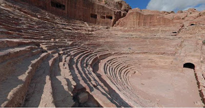
Petra, The Theatre  

Posted by Pocketeer in ,,

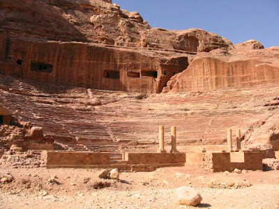
PetraPetra's theater was built in the 1st century AD. It is quite large, with a seating capacity of over 6,000 people. The theater's 45 rows of seats are divided horizontally by two diazomata . Its cavea faces north and east, to keep the sun out of the spectators' eyes. Above the cavea are numerous tomb fronts, which were destroyed to make way for the theater's upper tiers of seating.

Petra


Petra's theater is cut out of solid rock, and badly deteriorated. The front of the theater, including most of the stage was badly damaged by floods.

While some people have assumed that this was built by the Romans, the theater is actually Nabataean and was constructed long before the Romans entered Petra.

Share/Save/Bookmark

Urn-Tomb: The Royal Tombs in Petra  

Posted by Pocketeer in ,,

The first of the so called Royal Tombs is the Urn Tomb. This tomb is built high on the mountain side, and requires climbing up a number of flights of stairs. Abbe' Starcky has suggested that this is the tomb of Nabataean King Malchus II who died in 70 AD. Dr. Schmidt-Colinet on the other hand has proposed that this is the tomb of Aretas IV.

It had two layers of vaults and is thought to be the tomb of the Nabatean king, Malchus II. It was converted into a church by the Byzantines. They flattened the floor of the tomb and put in an altar


The Urn Tomb is a well-preserved monument facing an open terrace fronted by a double row of vaults. A colonnaded cloister runs along the northern side of the terrace. Behind the facade is a single, unadorned room measuring 60 feet on each side..


Share/Save/Bookmark

The Monastery at Petra  

Posted by Pocketeer in ,,

The Monastery, Petra's largest monument, dates from the first century BC. It was dedicated to Obodas I and is believed to be the symposium of Obodas the god. This information is inscribed on the ruins of the Monastery (the name is the translation of the Arabic "Ad-Deir").

Share/Save/Bookmark

Petra, the fabled "rose red city"  

Posted by Pocketeer in ,,

Petra "petra-πέτρα", cleft in the rock in Greek; Arabic: البتراء, Al-Batrāʾ) is an archaeological site in the Arabah, Ma'an Governorate, Jordan, lying on the slope of Mount Hor in a basin among the mountains which form the eastern flank of Arabah (Wadi Araba), the large valley running from the Dead Sea to the Gulf of Aqaba. It is renowned for its rock-cut architecture. Petra is also one of the new wonders of the world. The Nabateans constructed it as their capital city around 100 BCE.

The site remained unknown to the Western world until 1812, when it was introduced to the West by Swiss explorer Johann Ludwig Burckhardt. It was famously described as "a rose-red city half as old as time" in a Newdigate prize-winning sonnet by John William Burgon. UNESCO has described it as "one of the most precious cultural properties of man's cultural heritage." In 1985, Petra was designated a World Heritage Site.


Share/Save/Bookmark

Petra, the fabled "rose red city" Map  

Posted by Pocketeer in ,,


Share/Save/Bookmark

Prasat Muang Tam  

Posted by Pocketeer in ,


Prasat Muang Tam
It is just 8 km away from Prasat Phanom Rung, by a concrete road through paddy fields.

The temple is surrounded by a community called Ban Cho-ra-ke Mak. In front of the car park there is a small shop cum museum displaying books and photos of Khmer architecture. The entrance gate opposite the museum charges entrance fees (10 Baht for Thai and 30 Baht for a foreigner).

There are local houses, a Thai temple and a school nearby the Khmer sanctuary.

In the low tourist season the site looks solitary and magical. The complex is surrounded by two walls. The inner wall is made of sandstone while the outer one is made of laterite. Sandstone archways at opposite points perforate the perimeter on all four sides. The lintel, pediment, and side columns of each archway are carved into scenes from Hindu myth.

There are four L-shaped ponds located between the outer and inner walls. At the center of the compound there are 5 Chedis all made of brick and built on a single laterite foundation.

Share/Save/Bookmark

Prasat Phanom Rung  

Posted by Pocketeer in ,

From Korat take the highway no. 224 to the south to Chok Chai district (about 30 km). Then take to the left turn and continue on the road no. 24. It is approximately 77 km from Chok Chai to the intersection (in Nang Rong district) with signed road to Prasat Phanom Rung. Follow the concrete road for 12 km to get to the ancient hill top Khmer temple. The temple on the hill could be seen from a distance.

It is comprised of 13 main parts. Part one is the stairway starting near the car parking. From this point you could not see any buildings until you walk to the end of the stairway. Then there is a pavilion setting on the right side, at the end of the stairway.

The third section is the flat pathway with columns on both sides. It leads to "Naga bridge", the section four. Next, there are 52 steps leading to the top of the hill. This construction connects to part six, the bridge linking to principal tower.

Prasat Phnom Rung temple The second level Naga bridge, the boundary gallery, and the third level Naga bridge are located before the main building. The main square based tower is made of pink sandstone, which is 9.2 meters width and 23 meters tall.

At the center of the building there is the "Shiva Lingam ", the most sacred religious object. There are two stone building and one minor building to the northeast and the southwest of the main building. In front of the tower, to the northeast and the southeast, are two laterite buildings used as libraries.

Normally visitors would walk up the ladder from the bottom. However you can drive up to the summit and park just behind the compound for a fee of 50 Thai Baht for a van. Entrance fee for visitors is 40 Thai Baht each for foreigners, and 20 Thai Baht each for Thais.

Every year in April there is a cerebration. Many tourists come to celebrate and worship at this ruin. There are display of beautiful parades, north eastern style dinner, traditional shows, sound and light show. In 2003 the cerebration takes place on 5 and 6 April.
Share/Save/Bookmark

Thailand Travel Transport  

Posted by Pocketeer in ,

Main cities and touristic places are well connected by land (bus and train), and airlines. Here are some websites to check out the airlines schedules and other land transport within Thailand.

Airport Authority of Thailand.

Thai Airways
Bangkok Airways (Regional Airlines)
PB Air (Thailand domestic lines)
Air Asia (Budget airlines)
Nok Air (Budget airlines)
Laos Airlines
Myanmar Airways International

Transport Co., Ltd. (Thailand inter city bus lines)
Their English language pages

Railways of Thailand
Train schedules in .pdf (08 Mar 2006):
Eastern lines : Northern lines : North-eastern lines : Sourthern lines

Sea and river travel
There are no regular long distance boat and passenger ships services in Thailand. Many of Thai rivers are blocked by dams so effectively making such transport impossible. However there are many ferry boat including speed boat services linking the piers on islands and main land throughout the country.

When planning a trip to remote places in Thailand, Laos, Cambodia and Myanmar some people, especially the first timers, tend to under estimate the time required to travel. There are logistical matters to research and make details out of all available information.

FMM (Frequently made mistakes)
  • Whenever your flight arrives Bangkok (or any other city), you can always go to the bus station and take the bus to your destination wasting almost no time
    - Regular, every hour or every few hours, bus services exist between some crowded tourists places. But it is not true for many other destinations.
  • All roads you find on a map in Thailand are passable the whole year
    - There are some roads that are never finished but are shown on some maps (don't know why). Also there are some roads, especially those in the rugged lands, that can not be used during bad weather (rainy and flood/land slide seasons).
  • Every tourists destination can be reached from Bangkok or Chiang Mai almost straight, meaning without necessary to make hundreds of kilometers long detour.
    - There are many mountain, forest, national park, and wildlife sanctuary lands in Thailand. Roads passing these areas are mostly seasonal or are just foot paths. That makes it necessary to go a very long way around to get to certain destination.
  • Assume that there are no "gates" operating on opening and closing time.
    - When driving on the roads passing certain areas (for example, a national park) there are opening and closing time. As well when going across a river where there is no bridge you need to know the operating time of ferry boat service. Border gates here don't open 24 hours a day!
  • It is 160 km so the driving time should be 2 hours.
    - You need to check with good topographic map. If it is a mountain road going up and down and turning hundreds of curves then it could take 4 hours.
Therefore when you send us inquiry to arrange your trip please consider these transport logistics. If you have doubts let us help you plan your entire trip logistics. Even if you need our services for only some parts of the whole travel it will make sure you make a possible itinerary that you will enjoy without serious problems.

Share/Save/Bookmark

Buri Ram location on Thailand map  

Posted by Pocketeer in ,

1 = Chiang Rai (northernmost province)
2 = Mae Song Son
3 = Chiang Mai
4 = Sukothai
5 = Tak
6 = Kanchanaburi
7 = Bangkok (capital)
8 = Nong Khai (bridge across Mekong river to Vientiane)
9 = Khon Kaen
10 = Ubon Ratchathani

11 = Nakhon Ratchasima (Korat)
12 = Buri Ram
13 = SaKaeo
14 = Rayong
15 = Koh Chang island (in Trat province)
16 = Chumphon
17 = Ranong (across river/sea to Kaw Thaung)
18 = Koh Samui island (in Surat Thani province)
19 = Surat Thani
20 = Phuket island

21 = Narathiwat
22 = Satun

Share/Save/Bookmark

Phnom rung castle plan view  

Posted by Pocketeer in ,


Plan view of Prasat Phnom Rung temple (Buri Ram)

1 = Stairway
2 = Pavilion
3 = Pathway (flat)
4 = Naga bridge
5 = Stairway leading to the main tower
6 = bridge to the main tower
7 = Second level Naga bridge
8 = Boundary gallery
9 = Third level Naga bridge
10 = Main tower
11 = Minor tower
12 = Brick tower
13 = Library

Share/Save/Bookmark

Third Naga Bridge, Phnom Rung  

Posted by Pocketeer in ,

Naga Issuing From Makara,
Unusually, this balustrade (in front of the mandapa) shows the naga issuing forth from the mouth of a makara. There is a modern example located near Kamphaeng Yai.

Makara,A chimera that is part water-snake and part crocodile or fish, usually with an elephant snout. It is a frequent decoration on balustrades, arches, waterspouts, and offering overflow spouts

Naga,The water-snake, whose cultural iconography and mythology was inherited from India via Southeast Asia. In temple decoration, both the balustrade and the framing arches of niches and doorways are often carved in the shape of nagas (usually, in those cases, a snake's body with a makara head.)

Share/Save/Bookmark

How to get in to Petra the fabled "rose red city"  

Posted by Pocketeer in ,,

By bus

JETT buses, both ordinary and all-inclusive guided tour, connect to Amman and Aqaba. Other tourists come with organized groups, including daily trips from Eilatm. Tours to Petra from Taba, Sinai and Sharm el Sheikh are also gaining popularity with charter tourism.

By minibus

The minibus from Wadi Rum costs 3 Jordanian Dinars (JD) each. It takes 1.5 hours to get to Petra. Have the Rum Guesthouse or your tour operator call the bus owner the day before to arrange an exact time for pick up. The bus usually leaves from Wadi Rum at 8:30 in the morning, but may be delayed due to weather or tour groups coming the other way.

There are also minibuses from Amman departing from the Wadabat bus station - these leave when full, and tourists are almost always charged 3 JD to get on. DO NOT allow the drivers to charge you for your luggage, as they might sometimes try to do, considering you're already paying more than the locals (who pay 2-2.5JD).

By taxi

Taxi is also a viable option. For 75 JD or less (depending on how much you haggle) you may be able to get a private taxi from Amman to Petra and back, including the driver waiting around for 6 hours. It would cost 24 JD for two persons to travel by JETT bus, and allow you to see almost the entire site in an (exhausting) day trip.

If you get there renting a minibus with a driver in the hotel at the Dead Sea, the one-way price would be 140 JD.


Share/Save/Bookmark

Phnom Rung Castle  

Posted by Pocketeer in

Phnom Rung, on the royal road between Angkor and Phimai, was built early in the reign of Suryavarman II (1112-1152) by Narendraditya, a local ruler and kinsman of the king. The east-facing axial temple is built upon a hill ("phnom" means "hill" in the Khmer language). The temple is approached by a long east-west causeway (160m, or 530') that is lined with lotus-bud posts. The west end of the causeway is seen in this photo, where it abuts a naga-bridge like the one at Phimai. Crossing over the platform, one climbs the stairs to reach the temple enclosure.

Phnom Rung was built after Phimai and before Angkor Wat. It has several design features in common with both, particularly the use of naga bridges and the Khmer-type tower pioneered at Phimai. Yet, there is not a sense of progressive development in these three temples; Phnom Rung goes its own way, with a distinct triangular shape to its tower and an antarala (antechamber) between the entrance hall and sanctuary.


Share/Save/Bookmark

Petra, the fabled "rose red city"  

Posted by Pocketeer in ,,

Petra was the impressive capital of the Nabataean kingdom from around the 6th century BC. The kingdom was absorbed into the Roman Empire in AD 106 and the Romans continued to expand the city. An important center for trade and commerce, Petra continued to flourish until a catastrophic earthquake destroyed buildings and crippled vital water management systems around AD 663. After Saladin's conquest of the Middle East in 1189, Petra was abandoned and the memory of it was lost to the West.

The ruins remained hidden to most of the world until the Swiss explorer, Johann Ludwig Burckhardt, disguised as an Arab scholar, infiltrated the Bedouin-occupied city in 1812. Burckhardt's accounts of his travels inspired other Western explorers and historians to discover the ancient city further. The most famous of these was David Roberts, a Scottish artist who created a number of accurate and detailed illustrations of the city in 1839.


Share/Save/Bookmark

blog directory;GeekySpeaky: Submit Your Site!A1 Web Links -Blog Search, Blog Directory PageRank 5 Directory Cheap hotel deals Dmegs Web Directory Website Promotion Directory TopOfBlogs Join My Community at MyBloglog! Free Classifieds Ads Car Escorts Real Estate Cottage Dating SoMuch.com: Internet Links Directory
Your Name :
Your Email :
Subject :
Message :
Image (case-sensitive):